 |
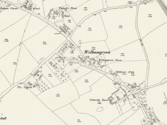
| Details from the 1898 OS map of Welham Green and Marshmoor Map courtesy of the Royal Library of Scotland |
The maps are from a collection of Ordnance Survey (OS) maps which have been curated and digitised by The National Library of Scotland (NLS) and released under the terms of the Creative Commons International 4.0 licence. Click on the maps below to view in full screen on the NLS site.
For this selection we have chosen to show the 25 inch to the mile maps that are available on the NLS site because they are the largest scale and show the most detail when you zoom in.
1898
Click here or on the map below to view in full screen on the NLS site.
 |
| The 1898 OS map of Welham Green and Marshmoor Map courtesy of the Royal Library of Scotland Click on the map to view in full screen |
1924
Click here or on the map below to view in full screen on the NLS site.
 |
| The 1924 OS map of Welham Green and Marshmoor Map courtesy of the Royal Library of Scotland Click on the map to view in full screen |
1937
Click here or on the map below to view in full screen on the NLS site.
 |
| The 1937 OS map of Welham Green and Marshmoor Map courtesy of the Royal Library of Scotland Click on the map to view in full screen |
Comments and information welcome

If you have anything to add to this feature, or just want to add your comments, please use the comment box below.
No comments:
Post a Comment
Comments on this piece
If you have any information to add to this item, please use the comment box below. We welcome input and are keen to update any piece with new research or information. Comments are pre-moderated, so there will be a delay before they go live. Thanks
Further information
If you require any further information relating to this, or any other item, please use the contact form, because we are unable to reply directly to you via this comment box. You can access it from the 'contact us' link at the top of any page on the website, at the bottom of the right hand side of the website, or at the bottom of any page.