Welcome to the North Mymms History Project

A growing collection of books, features, images, documents, and maps, collected, curated, and presented by a team of local volunteers keen to preserve the history of North Mymms

Booth tomb North Mymms parish church

North Mymms Notes - No 13


Photograph of The Grade II listed Booth tomb at St Mary's Church, North Mymms - August 2018 Image by the North Mymms History Project released under Creative Commons BY-NC-SA 4.0
The Grade II listed Booth tomb at St Mary's Church, North Mymms - August 2018
Image by the North Mymms History Project
Released under Creative Commons BY-NC-SA 4.0

In August 2018 work was completed on the restoration of a Grade II listed tomb in the churchyard at St Mary's church, North Mymms..

The tomb, known locally as the Booth tomb, is the burial place of Mary Booth who died in 1807, and her husband Frederick Booth who died in 1831.

Local historian and photographer Mike Allen has been researching the history of the tomb in his North Mymms Notes series.

Folly Arch through the ages

Tracing the history of the North Mymms landmark


Folly Arch  c1920  Note the ivy growth on south elevation Image from the Peter Miller Collection
Folly Arch c1920 Note the ivy growth on south elevation
Image from the Peter Miller Collection
Folly Arch has stood as a prominent North Mymms landmark since the first half of the 18th century. Local historian and archivist Peter Miller has been researching the history of the Grade II* listed structure and its eventful journey to the present day.

Marshmoor train derailment 1946

"Troublesome" section known to railworkers


Marshmoor train derailment 1946 -  Image from the Peter Miller Collection
Image from the Peter Miller Collection
At 10.35pm on Sunday 10 November 1946 a London-bound express train derailed about 200 yards south of the Dixons Hill Road bridge, Welham Green.

The train had left Newcastle at 4.45pm on its way to King's Cross. It was made up of 12 carriages hauled by a type V.2 class engine travelling at about 55 mph.

The entire train derailed, apart from the leading wheels of the engine.

North Mymms fatal train derailment Boxing Day 1870

Eight dead, including two local women


Great Northern Railways Stirling 4-2-2 1001, introduced in 1870 Image courtesy of Tony Hisgett from Birmingham released under CC BY 2.0
Great Northern Railways Stirling 4-2-2 1001, introduced in 1870
Image courtesy of Tony Hisgett from Birmingham released under CC BY 2.0

On a frosty Boxing Day evening in 1870 a wheel on a north-bound train travelling through North Mymms fractured sending carriages down the embankment at the Marshmoor railway crossing near Welham Green.

Eight people died on that cold evening, including two local women - sisters-in-law - who were walking close to the line. Three people were injured.

Mysterious death of a Victorian railway lad

The short life of a North Mymms teenager


Had it not been for the curiosity of a four-year-old boy, walking with his dad through the churchyard of St Mary's North Mymms, this story may have never been told.

But the inquisitive mind of the child, who wanted to know what was written on the headstones and the stories behind those buried in the graves, resulted in a father and son research project that uncovered a moving and tragic story of Victorian life and death.

This feature about the short life of railway worker Herbert George Town, from Marshmoor, was written by David Lister with the help of his son. It was first published in the April 2002 edition of the St Mary's church magazine.

Top secret WWII Russian visit to Brookmans Park 1942

Local residents left totally in the dark


Golden Fleece arriving at Brookmans Park station on 21 May, 1942 Screen grab courtesy of the Imperial War Museum non-commercial licence
Golden Fleece arriving at Brookmans Park station on 21 May, 1942
Screen grab courtesy of the Imperial War Museum non-commercial licence
On Thursday, 21 May, 1942, Class A4 locomotive Number 4495 'Golden Fleece' arrived at Brookmans Park Station. (1)

On board was the Russian Peoples' Commissar for Foreign Affairs Vyacheslav Molotov, along with his staff. British Foreign Secretary, Anthony Eden, was there to meet his Russian counterpart.

This wasn't a scheduled service; this was a special train laid on to carry a Russian delegation on its way to attend a top-secret meeting which would lead to the signing of the Anglo-Soviet Treaty.

North Mymms film locations from the early 1900s

From silver screen to TV series and TV adverts


Steed driving through the gates at P.U.R.R.R. , North Mymms Park  Screen grab from http://averagerslocations.blogspot.com
Steed driving through the gates at P.U.R.R.R. , North Mymms Park
Screen grab from http://averagerslocations.blogspot.com

North Mymms has had its fair share of exposure in TV series and in feature films. Perhaps it's because of the proximity of the parish to the Elstree Studios, perhaps it's the mix of suitable locations, or perhaps it's both of these.

The North Mymms History Project is compiling a list of the locations in the parish that have been used for filming. This will be a continually-updated feature as we research old and new scenes filmed around the parish. If you known of any films or TV series shot in North Mymms, please let us know.

1914 sale of parts of Brookmans Estate

1,204 acres of "valuable and improving investments"


Cover of the 1914 sale of elements of the Brookmans Estate from the Peter Miller collection


At 3pm on Wednesday July 1, 1914, 1,204 acres of the Brookmans Estate went under the auctioneers hammer. Among the lots were a number of local farms, an old manor house, several small holdings with cottages, "valuable building land", and old and well-timbered pastures described as "valuable and improving investments".

Bell Bar's last 19th century coaching inn demolished

Site of White Swan cleared to make way for flats


The Swan, Bell Bar, in the 1900s Image from the NMLHS, part of the Images of North Mymms collection
The Swan, Bell Bar, in the 1900s
Image from the NMLHS, part of the Images of North Mymms collection

The last of Bell Bar's former coaching inns was reduced to rubble in October 2018, marking the end of an era for the once-thriving North Mymms community.

In the 18th century, Bell Bar was an important staging post for those making the trip north from London.

Located on the Great North Road, at the 17-mile point from central London, the hamlet of Bell Bar was approximately a day's journey from the capital by horse-drawn carriage.

In October 2018 the Swan, which had been a private residence since the 1960s, was reduced to rubble to make way for a block of flats.

North Mymms then and now in pictures

Exploring our archive to see how the parish has changed


Man walking along Hawkshead Road towards Little Heath  Mix of photographs by R Kingdon (1967) and the North Mymms History Project (2018)  Montage by North Mymms History Project, released under Creative Commons
Man walking along Hawkshead Road towards Little Heath 1967/2018
Mix of photographs by R Kingdon (1967) and the North Mymms History Project (2018)
Montage by North Mymms History Project, released under Creative Commons

The North Mymms History Project has been comparing some of the old photographs in our archive with modern-day shots of the same scenes to show how the parish has changed.

With more than 4,000 images to choose from, we can offer just a small sample in this feature, but we have added links at the end of the piece to other photographic features on the site for those who want to carry out their own research.

1946 Marshmoor train derailment - official report

Ministry Of Transport Accident Inquiry


The official report by the Ministry of Transport into the derailment at Marshmoor on the London and North Eastern Railway on 10 November, 1946. Seven passengers complained of minor injuries and shock, but none required hospital attention. The document is from the Peter Miller Collection.

Timber production in North Mymms

The importance of wood to the local economy


Harold Spencer and Bob Rogers at Woodside Place in the 1900 Image from P. Grant / G. Knott
Harold Spencer and Bob Rogers at Woodside Place in the 1900s
Image from P. Grant / G. Knott, part of the Images of North Mymms Collection

North Mymms once had a thriving timber industry. Wood was grown and farmed as a felling crop on all the large estates in the parish. In one year alone, an "exceptionally wealthy" local landowner planted 40,000 oaks in a 27-acre field in Gobions.

Local wood production was such, that large auctions were held in the parish to sell the timber, with buyers notified via the press throughout Hertfordshire, Buckinghamshire, Essex, Cambridgeshire, and Middlesex.

Mighty Men of Mymms online memorial


Mike Allen, one of the North Mymms History Project's team of four, has spent more than six years researching the stories of the 59 men from the parish of North Mymms who died while serving, or as a result of serving, in WWI.

Mike started the project in 2012. In October 2018 the material was made available online for the first time, scheduled to coincide with the 100th anniversary of the end of the Great War of 1918-1918.

Vicars of St Mary's North Mymms since 1237

North Mymms Notes - No 18


Brass of William de Kestevene, priest at St Mary's from 1344 until his death in 1361  Image by the North Mymms History Project, released under Creative Commons BY-NC-SA 4.0
Brass of William de Kestevene, priest at St Mary's from 1344 until his death in 1361
Image by the North Mymms History Project, released under Creative Commons BY-NC-SA 4.0

In the 780 years since the first priest conducted a service at St Mary's, North Mymms, there have been 57 men and, more recently women, serving in the role. The average time in the post is almost 14 years.

Mike Allen, one of those behind the North Mymms History Project has researched the history of the priests, or vicars as they were later known, of St Mary's church, North Mymms.

North Mymms WWI and WWII war graves

Photographs, maps and details of the nine graves


Photograh of The nine war graves in St Mary's churchyard, North Mymms  Image by the North Mymms History Project, released under Creative Commons BY-NC-SA 4.0The nine war graves in St Mary's churchyard, North Mymms  Image by the North Mymms History Project, released under Creative Commons BY-NC-SA 4.0
The nine war graves at St Mary's, North Mymms
Image by the North Mymms History Project, released under Creative Commons BY-NC-SA 4.0

During the two World Wars, serving members of the armed forces who were killed abroad were buried in Commonwealth War Cemeteries near to where they fell.

Those who died in the UK were, in many cases, buried in their local cemeteries. Those who had left the service but died subsequently from wounds received may be buried in their local churchyard but not in War Graves.

The North Mymms History Project's Mike Allen has been researching the war graves of St Mary's, North Mymms.

The history of Little Heath Wood House

Cover of A personal record of Gresley Court from 1972 and the history of Little Heath Wood House' by Joan E. Gooding


A book written and produced by a long-term resident of Gresley Court, Little Heath has just been published. The book is entitled 'A personal record of Gresley Court from 1972 and the history of Little Heath Wood House'. The author is 90-year-old Joan E Gooding.

The first half of the book deals with the history of the management company of Gresley Court. The second half looks at the history of Little Heath Wood House, which previously occupied the site, and which was the earliest large house built in Little Heath forming a small estate with its own farm.

Sale of outlying portions of North Mymms Park Estate 1922

800 acres of farms, land, and cottages 


Scan of the front cover of the 1922 auctioneer's brochure Brochure courtesy of Lindsay Sinclair, scan by Mike Allen Image released under Creative Commons BY-NC-SA 4.0
Scan of the front cover of the 1922 auctioneer's brochure
Brochure courtesy of Lindsay Sinclair, scan by Mike Allen
Image released under Creative Commons BY-NC-SA 4.0

At 4pm on Wednesday the 26th of July, 1922, 800 acres of North Mymms Park went under the auctioneer's hammer. Twenty lots were up for sale, including farms, land, and cottages.

A 15-page sales brochure featuring some of the biggest farms in the parish was produced for the event, held at the Peahen Hotel in St Albans.

The North Mymms History Project has been loaned a copy of the sales details which we have digitised and included below.

Rare pictures of North Mymms Park uncovered

Old photographs digitised and enhanced


Photograph South elevation showing the 1846/7 double bay hall which was later replaced in 1893  Image courtesy of Lindsay Sinclair and released under Creative Commons BY-NC-SA 4.0
South elevation showing the 1846/7 double bay hall which was later replaced in 1893
Image courtesy of Lindsay Sinclair and released under Creative Commons BY-NC-SA 4.0
A collection of old photographs of North Mymms Park, thought to have been taken in 1876, has been discovered and shared with the North Mymms History Project.

It's thought the images could be the earliest known photographs of the park, predating those held by Historic England.

Victorian farming and land ownership changes in North Mymms

How the parish evolved at the end of the 19th century


Photograph of Jack Honour ploughing September 1914
Jack Honour ploughing in September 1914
Photograph from the Images of North Mymms Collection

At the end of the 19th century the agricultural economy of North Mymms was undergoing dramatic change. A run of cold, damp summers had seen crops fail and incomes fall. Smaller farms were struggling. At the same time, wealthy professional people, whose economic focus was on London, were moving into the area seeking their own little patch of the rural experience. The area's demographic and agriculture were both undergoing rapid change.

Life as a tramp in Victorian Hertfordshire

An early example of undercover journalism


Image courtesy of Dr Peter Jones, Early Career Lecturer in Urban History After 1800  Centre for Metropolitan History, Institute of Historical Research, University of London
Image courtesy of Dr Peter Jones, Early Career Lecturer in Urban History After 1800
Centre for Metropolitan History, Institute of Historical Research, University of London

Almost 150 years ago, the journalist and writer James Greenwood disguised himself as a homeless person and walked the length of Hertfordshire in order to experience, first hand, what life was like for a tramp in Victorian England.

He wrote about the fellow travellers he met on the way and the degrading conditions they faced. His journey took him through North Mymms. Stopping at the White Swan in Bell Bar he witnessed confidence tricksters using their misfortune to try to eke out a living.

Virtual tour of St Mary's Church, North Mymms

Discover the history of St Mary's in 3D


St Mary church North Mymms taken in June 2015 Image by the North Mymms History Project released under Creative Commons BY-NC-SA 4.0
St Mary church North Mymms taken in June 2015
Image by the North Mymms History Project released under Creative Commons BY-NC-SA 4.0

For those not able to visit North Mymms parish church, this site now has a virtual three dimensional tour of the inside of St Mary's. The interactive slideshow highlights many of the historical features of the church.

Reverend Leonard Buxton of St Mary’s North Mymms

Serving North Mymms through WWII


The Rev Leonard Buxton and his family prior to their arrival at St Mary's, North Mymms  Image by Olive Edis, courtesy of the Cromer Museum, Norfolk
The Rev Leonard Buxton and his family prior to their arrival at St Mary's, North Mymms
Image by Olive Edis, courtesy of the Cromer Museum, Norfolk 

A couple of family photographs of the Reverend Leonard Buxton, his wife Kathleen, and their six children have been acquired by a museum in Norfolk. The Rev Buxton was the vicar of St Mary’s, North Mymms from 1930 to 1944. The curator of the Cromer Museum has send digital copies of the images to the North Mymms History Project so that they can be shared on this site.

Historical treasures of the parish church of St Mary, North Mymms

A series of features from the 2004 and 2005 parish magazines


The church of St Mary, North Mymms, taken in August 1966 Image by Ron Kingdon, part of the Images of North Mymms Collection
The church of St Mary, North Mymms, taken in August 1966
Image by Ron Kingdon, part of the Images of North Mymms Collection

Introduction


The following is a reproduction of a series of articles about the historical aspects of the fabric of St Mary's church, North Mymms. They were written for the parish magazine by Patricia Cook, a former churchwarden, and were published intermittently during 2004 and 2005. The articles, which were later put on the St Mary's Church website in a feature entitled 'Know Your Church', are reproduced here with the permission of the church. The North Mymms History Project has also been given permission to reproduce the original line drawings by local artist Jean Atkinson, who has been closely involved with St. Mary's for many years, including serving on the parochial church council. We have added modern-day photographs of the items Jean sketched at the foot of this piece.

A short history of the parish church of St Mary, North Mymms


Introduction 


ostcard of the parish church of St Mary, North Mymms in the 1900s Image from J Potter, part of the Images of North Mymms Collection
Postcard of the parish church of St Mary, North Mymms in the 1900s
Image from J Potter, part of the Images of North Mymms Collection

The original version of this booklet about the history of the parish church of St Mary, North Mymms, was compiled by local historian and teacher Dorothy Colville in 1962. It sold for 6d. It was revised and reprinted in 1977 and 1983, with a revised price of 3p, and updated and reprinted again in 1990. The North Mymms History Project has transcribed the booklet and embedded the original below. The booklet is from the Peter Miller Collection and was digitised by Mike Allen.

HM Alderman on the bells of North Mymms

Introduction


Councillor H.M. Alderman fourth fromleft attending a North Mymms Parish Council meeting in 1957 Image courtesy of NMPC and part of the Images of North Mymms Collection
Cllr H.M. Alderman, fourth from the left, attending a North Mymms Parish Council meeting in 1957
Image courtesy of NMPC and part of the Images of North Mymms Collection

70 years ago a series of articles appeared in the North Mymms Parish Magazine about the history of St Mary’s Church. They were written by Harry Maynard Alderman, a local writer, historian, accomplished artist, carpenter, and parish councillor.  In the 1940s and 1950s Mr Alderman was a frequent contributor to the parish magazine, writing serialised articles about St Mary’s church, including pieces about the history of the bells, the brasses, and the fabric of the church.

The North Mymms History Project has transcribed the series about the bells of St Mary’s from copies of the magazine published in December 1950 and in January, March, April, and May 1951. The source material is courtesy of the Peter Miller Collection.

Maintaining the tombstones of North Mymms

A call, 50 years ago, to preserve parish memorials


Dorothy Colville's own tombstone in the new burial ground at St Mary's North Mymms Image by the North Mymms History Project, released under Creative Commons BY-NC-SA 4.0
Dorothy Colville's own tombstone in the new burial ground at St Mary's North Mymms
Image by the North Mymms History Project, released under Creative Commons BY-NC-SA 4.0

Introduction


The image above is of the tombstone for Dorothy Colville, local teacher and historian, who is buried at St Mary's, North Mymms. Dorothy, the author of the book North Mymms Parish and People, cared passionately about North Mymms and the preservation of its history.

Half a century ago she wrote an article entitled 'A plea for tombstones', published in the Hertfordshire Countryside magazine in September 1969. The North Mymms History Project has reproduced the feature below, and embedded a copy of the original piece at the foot of the page.

We have also added some recent images of the tombstones which Dorothy wrote about to show how they have aged over the last 50 years.

Restoration of the belfry at St Mary's, North Mymms

Replacing rotten oak, retuning almost three tons of bells


John Wiseman, a St. Mary’s ringer, preparing for the removal Image by Jane Russell (nee Sherlock) released under Creative Commons BY-NC-SA 4.0
John Wiseman, a St. Mary’s ringer, preparing for the removal of the bells in early 1985
Image by Jane Russell (nee Sherlock) released under Creative Commons BY-NC-SA 4.0

Bell tower falls silent for three months


In early 1985 the bells at St Mary's, North Mymms, were lowered from the belfry that most had occupied for almost 180 years. The oak frame which had been supporting them had begun to rot. Woodworm had damaged the beams. The old oak had been supporting six of the eight bells weighing almost two and a half tons. The parochial church council (PCC) feared the frame might collapse, causing damage to the 800-year-old tower. So an extensive refurbishment plan was put in action costing an estimated £20,000 pounds.

The Burns Family of North Mymms Park 1893-1997

North Mymms Notes - No 16

By Mike Allen


North Mymms House, the 1900s extension on the left Image from A Nott / G Knott, part of the Images of North Mymms Collection
North Mymms House, the 1900s extension on the left
Image from A Nott / G Knott, part of the Images of North Mymms Collection

Introduction


In this edition of North Mymms Notes, Mike Allen looks at the history of the Burns family of North Mymms Park, who had a large part to play in the development of the parish during the late 1800s and early 1900s. This latest issue (No 16) is reproduced on this site with Mike's permission. This feature has been edited and formatted for the web. The original piece is embedded below.

The Woodman, Water End

North Mymms Notes number 20


The Woodman Inn, Warrengate Road, Water End - July 2018
Image by the North Mymms History Project released under Creative Commons BY-NC-SA 4.0

Introduction


Built in the late 17th or early 18th century, The Woodman Inn at Water End is a Grade II listed building with an interesting history. Local resident, historian, and photographer, Mike Allen, has traced the pub's past in this latest issue (number 20) of his North Mymms Notes, reproduced on this site with his permission.

Mason marks of St Mary's Church, North Mymms

North Mymms Notes number 17


St Mary's Church, North Mymms, which has mason marks on some of the tower steps - July 2018 Image by the North Mymms History Project, released under Creative Commons BY-NC-SA 4.0
St Mary's Church, North Mymms, which has mason marks on some of the tower steps - July 2018
Image by the North Mymms History Project, released under Creative Commons BY-NC-SA 4.0

Introduction


In this articles in Mike Allen's series of North Mymms Notes he looks at the history of the mason marks that have been etched in the stairs leading to the tower at St Mary's Church, North Mymms. Mike has researched why they were made, what they stand for, and why so little is known about the men who helped build the parish church.

The wells, windpumps, and water towers of North Mymms

Producing water "sufficient in quantity, good in quality"


Photograph of The windpump and well at the side of Love Lane, North Mymms Park - August 2018 Image by the North Mymms History Project released under Creative Commons BY-NC-SA 4.0
The windpump and well on the west side of Love Lane, North Mymms Park - August 2018
Image by the North Mymms History Project released under Creative Commons BY-NC-SA 4.0

In 1911, fewer than a quarter of the 404 homes in North Mymms had a constant mains water supply piped to the premises. The rest had to rely on an estimated 53 active wells dotted around the parish. A health inspector's report at the time noted that the water extracted from the wells was "sufficient in quantity and good in quality". Four of those wells were still supplying water for 20 homes more than half a century later, but, by then, the quality was described as only "satisfactory".

Historical North Mymms tomb engulfed in ivy


Note: This article was published on North Mymms News on August 13, 2018. It is reproduced here as part of the North Mymms History Project's news archive.


Grade II listed monument no longer visible


Photograph of The overgrown Grade II listed tomb at St Mary's Church, North Mymms - August 2018 Image by the North Mymms History Project released under Creative Commons BY-NC-SA 4.0
The overgrown Grade II listed tomb at St Mary's Church, North Mymms - August 2018
Image by the North Mymms History Project released under Creative Commons BY-NC-SA 4.0

A tomb in the churchyard at St Mary's, North Mymms, which was listed as a Grade II historical monument in 1983, is now completely covered in ivy. It's not known whether any damage has been caused, but church representatives are to meet to consider how best to tackle the problem. Earlier this month the restoration of another listed tomb in the churchyard was completed. That repair cost several thousand pounds and took two years. That, too, had been covered in ivy in the 1900s.

The 45 listed historical sites of North Mymms

Moffats Farm Farmhouse a Grade II listed building Image by the North Mymms History Project released under Creative Commons BY-NC-SA 4.0
Moffats Farm Farmhouse is a Grade II listed building
Image by the North Mymms History Project
Many will pass some of the 45 listed sites in North Mymms every day without realising that these protected properties and landmarks are now a preserved part of the nation's history. Some travelling by train or road probably pass two hidden in the undergrowth and bushes. The North Mymms History Project has used data, compiled by Historic England, to create an interactive map of all the listed sites in the parish. We have also produced a slideshow featuring all 45 listed sites.

South Hertfordshire's coal posts

Photograph of The listed coal post on Heath Road, Little Heath Image by the North Mymms History Project released under Creative Commons BY-NC-SA 4.0
The listed coal post on Heath Road, Little Heath (Grid Ref: TL257023)
Image by the North Mymms History Project released under Creative Commons BY-NC-SA 4.0

You might have passed them in the car, by train, or on foot, and you probably won't have given them a second glance. But if you had travelled the same way 150 years earlier, you might have found queues of people, many with carts loaded with coal, wine, clothing and food, haggling with the taxman. They are the coal tax posts, many of which were erected following the Coal Duties Act of 1851, and, thanks to them, funds were raised to construct many of the bridges across the Thames.

Fairview, saved from development, preserved for its history

North Mymms Notes - No 15


Photograph of Fairview taken in August 2018 Image by North Mymms History Project, released under Creative Commons BY-NC-SA 4.0
Fairview, a Grade II listed building photographed in August 2018
Image by North Mymms History Project, released under Creative Commons BY-NC-SA 4.0

In 1974 the owner of Fairview, a 140-year-old house on Welham Green's Station Road, wanted to demolish it and build two semis and two detached houses with garages. But North Mymms Parish Council took out a preservation order, the Department of the Environment agreed, and Fairview was saved. Now it is one of 10 Grade II listed buildings in the village protected from development.

The paintings that survived the destruction of Brookmans

Artwork, rescued from the flames now on display in Australia


Drawing of Brookmans House by Buckler, 1840 Image courtesy of Hertfordshire County Records Office (HCRO)
Drawing of Brookmans House by Buckler, 1840
Image courtesy of Hertfordshire County Records Office (HCRO)

On July 11, 1891, fire swept through and eventually destroyed Brookmans, a large country manor house standing in grounds that now make up the golf course and much of the surrounding area. Staff tried to rescue as much as possible from the mansion that gave its name to Brookmans Park, some valuables were saved, but much was lost.

Now, thanks to research by this site's resident historian and archivist, Peter Miller, some of those paintings, which were presumed to have been destroyed, have been traced - to Australia.

This is the story of a collection of paintings that survived the destruction of Brookmans, was put in storage for 60 years, and which is still being enjoyed, more than 120 years later, on the other side of the world.

Beating the bounds in North Mymms parish

Marking the parish boundary


Photograph of Beating The Bounds in August 1950 - Pauline Speary, June Chuck, Dorothy Speary. Image from D Denchfield digitally enhanced by Mike Allen
Beating the bounds in August 1950 - Pauline Speary, June Chuck, Dorothy Speary.
Image from D Denchfield, part of the Images of North Mymms collection


A centuries-old tradition


The ancient tradition of "beating the bounds", has been taking place in North Mymms for centuries. It involves a 17.5 mile walk along the parish boundary to visit, and ceremonially claim on behalf of the parish, various landmarks.

The natural history around Water End

Photograph of the path through the swallow holes at Water End, Hertfordshire


The following text was written for a geological walk around North Mymms in October 2004. It's been included in the North Mymms History Project because of its natural historical value. This site thanks Mike Howgate M.Sc, who is the recorder for geology for Hertfordshire, for giving us permission to reproduce his work.

Historical and geographical maps of North Mymms

Interactive and information-rich


The North Mymms History Project has compiled a collection of maps to help illustrate some of the historical and geographical features on the site. All the maps below have been created using Google Maps and include data compiled by the project, or data freely available via various open data programmes.

There are other maps on the site, but they are scans of historical maps that have been embedded in various articles after the North Mymms History Project obtained permission to reproduce the work.

The North Mymms War Memorial

A memorial to the 60 who died in the two world wars


Photograph of the south side of the war memorial with Tollgate Road beyond. Image by the North Mymms History Project released under Creative Commons
The south side of the war memorial with Tollgate Road beyond
Image by the North Mymms History Project released under Creative Commons

The North Mymms war memorial outside North Mymms Park has the names of 60 local men who are known to have died in WWI and WWII. On one side of the octagonal base are listed the names of the 40 who died in the so-called Great War of 1914-18. On the other side are the names of the 20 'who fell' in the 1939 - 1945 war.

The Mimmine Domesday Book entry

North Mymms almost a thousand years ago


Painting of Domesday Book writers by Joseph Martin Kronheim (1810–96) in the public domain, via Wikimedia Commons
Writing the Domesday Book
By Joseph Martin Kronheim (1810–96) in the public domain, via Wikimedia Commons

In 1086, North Mymms, formerly known as Mimmine, was surveyed by assessors following an order by the king, William the Conqueror. The king wanted a record of how land was distributed (who owned what), and to work out what taxes were due to the Crown. It was to be a detailed survey, listing not only every piece of land, but also every person, and every farm animal, "not even an ox, nor a cow, nor a swine was there left, that was not set down in his writ". The document containing this information was known as the Domesday Book.

Postal services in North Mymms over the years

Photograph of postman collecting the post from Holloways Lane, Welham Green in 1966 Image from Ron Kingdon part of the Images of North Mymms collection
Postman collecting the mail from a post box Holloways Lane, Welham Green in 1966
Image from Ron Kingdon part of the Images of North Mymms collection
In the summer of 1972, local historian and photographer, Ron Kingdon, wrote an article expressing his sadness at the loss of the Rookery post box near his home in Welham Green. Ron wrote: “The facility of slipping down to the corner to post a letter, as must have been done for many years here, came to an end on that Sunday in July.”

Post boxes in North Mymms from Victorian times

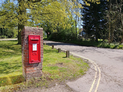
Photograph of Wall box GR at the top of Bell Lane at junction with the A1000 Great North Road, Bell Bar Image from the North Mymms History Project released under Creative Commons

There are 15 post boxes in the parish of North Mymms, one dating back to Victorian times. The North Mymms History Project has mapped and photographed those still in service as of May 2018, and has also researched the post boxes that served the parish in the past.

North Mymms From above 1960s

From our aerial photography over North Mymms series


Aerial photograph of Brookans Park, Hawkshead Lane, Water End and North Mymms Park taken in the 1960s Image from the NMLHS part of the Peter Miller collection

This collection in our series of aerial photographs taken over North Mymms features images shot in the 1960s. This six-image gallery has been uploaded in order to show how the parish has changed over the years.

Bell Bar from above 1947

From our aerial photography over North Mymms series


Photograph of Bell Lane, The Legg and Brookmans Park Golf Course, Bell Bar, 1947 Image courtesy of Britain From Above
Bell Lane, The Legg and Brookmans Park Golf Course, Bell Bar, 1947
Image courtesy of Britain From Above
This site has downloaded 50 aerial images taken over North Mymms in the 1920s, '40s and '50s. They are from the Britain From Above project and show how the area has changed over the years. This collection was taken over Bell Bar in 1947.

North Mymms from above 2002

From our aerial photography over North Mymms series


Image © Paul Large of Falcon Media, all rights reserved Permission to publish granted for this site only
Image © Paul Large of Falcon Media, all rights reserved
Permission to publish granted for this site only
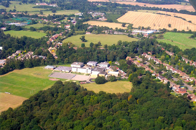
These aerial photographs were taken over North Mymms in September and October 2002. The images include shots of Water End, Hawkshead Lane, the Royal Veterinary College (RVC), Brookmans Park, Chancellor's School, Brookmans Park Primary School, and the Brookmans Park Transmitting Station.

Welham Green from above 1947-54

From our aerial photography over North Mymms series


Photograph of The Dottridge Brothers Ltd Coffin Factory at Marshmoor and environs, Welham Green, from the north-east, 1952. This image was marked by Aerofilms Ltd for photo editing. Courtesy of the Britain From Above project
Dottridge Brothers Ltd Coffin Factory at Marshmoor, Welham Green, from the north-east, 1952.
This image was marked by Aerofilms Ltd for photo editing and is courtesy of the Britain From Above
This site has downloaded 50 aerial images taken over North Mymms in the 1920s, '40s and '50s. They are from the Britain From Above project and show how the area has changed over the years. This collection shows how Welham Green has developed since 1947-54.

Brookmans Park from above 1947

From our aerial photography over North Mymms series


Photograph of Brookmans Park Railway Station and the London & North Eastern Railway line (LNER), Brookmans Park, 1947 Image courtesy of Britain From Above
Brookmans Park Railway Station and the London & North Eastern Railway line (LNER) 1947
Image with original caption courtesy of Britain From Above

This site has downloaded 50 aerial images taken over North Mymms in the 1920s, '40s and '50s. They are from the Britain From Above project and show how the area has changed over the years. This collection shows how Brookmans Park has developed since 1947.

Brookmans Park from above 1928-29

From our aerial photography over North Mymms series


Photograph of North Mimms and George's Wood, Brookmans Park, 1928 Image courtesy of Britain From Above
North Mimms and George's Wood, Brookmans Park, 1928
Image courtesy of Britain From Above

This site has downloaded 50 aerial images taken over North Mymms in the 1920s, '40s and '50s. They are from the Britain From Above project and show how the area has changed over the years. This collection shows how Brookmans Park has grown in terms of housing and population since 1928-29.

Bell Bar's WWII Tett turret and tank traps

Was this defending the Brookmans Park Transmitting Station?


The Bell Bar Tett turret, North Mymms, Hertfordshire Photograph by the North Mymms History Project Released under Creative Commons BY-NC-SA 4.0
The Bell Bar Tett turret, North Mymms, Hertfordshire
Photograph by the North Mymms History Project
Released under Creative Commons BY-NC-SA 4.0

Close to a public footpath to the east of Woodside Lane and to the north of the A1000 Great North Road lies a heap of concrete and metal. It appears to be the remains of a Tett turret, part of the WWII defences. Almost directly to the west, at the side of Woodside Lane, are seven tank traps, part of the same wartime anti-invasion precautions. Clearly, Bell Bar was a strategic spot during the war.

Foundling Hospital wet nurses of North Mymms

Scan of The Foundling Hospital, Holborn, London: a bird's-eye view of the courtyard. Coloured engraving by T. Bowles after L. P. Boitard, 1753. Image from Wikimedia Commons

The Foundling Hospital, Holborn, London: a bird's-eye view of the courtyard
Coloured engraving by T. Bowles after L. P. Boitard, 1753
Image from Wellcome Images via Wikimedia Commons

In the mid 1700s a register was kept of local nursing mothers who were prepared to feed and nourish unwanted babies from the Foundling Hospital in London. In North Mymms, South Mimms, London Colney, St Albans, and Hatfield, there were a total of 80 women named. Seven lived in North Mymms and six in South Mimms, with five in Colney Heath.